¶ DPOS with JAVAD Mobile Tools for Android
1. What is DPOS
2. JAVAD Mobile Tools J-Mobile
3. DPOS scenarios:
3.1. DPOS instead of post-processing with CORS
3.2. DPOS base-rover post.processing with DPOS
3.3. VB-RTK with local base
3.4. Hybrid RTK
4. Post-processing data collection
4.1. Recording data to files in receiver
4.2. Receiver indicators and status bar
4.3. Program receiver to auto finish data logging
4.4. Log history
4.5. Reconnection to monitor
4.6. Data downloads
4.6. Organise data to projects
4.7. Data exchange
4.8. Deleting raw files for free space
5. Data processing with Justin
5.1. Exchange data with PC
5.2. Manual file copying
5.3. With cloud services, email, instant messenger etc
5.4. With Justin Link browser
5.5. Process data in Justin
6. Data processing with NGS OPUS
6.1. Send data
6.2. Receiving report to your email
6.3. Receiving report to application with jmt@javad.com email
7. Data processing with JAVAD DPOS
7.1. Processing with CORS
7.1.1. Servers
7.1.2. Networks
7.1.3. Engines
7.1.4. Result storing
7.1.5. Review results
7.1.6. Export to catalog
7.2. Processing base-rover
7.3. VB-RTK
7.3.1. VB-RTK theory
7.3.2. Staring RTK base with recording
7.3.3. Starting RTK rover and surveying
7.3.4. Download base file
7.3.5. DPOS base file for VB-RTK
7.4. Hybrid RTK
7.4.1 Set Hybrid RTK Parameters
7.4.2. Survey RTK
7.4.3. Download Hybrid RTK files
7.4.4. Download RTK base file
7.4.5. Process Hybrid RTK files on DPOS
¶ 1. What is JAVAD DPOS
In USA now most surveyors use National Geodetic Service (NGS) Online Positioning User Service (OPUS) instead of desktop post-processing software. It collects data from Constantly Operational Reference Stations (CORS) permanently working around all continent, process your files with them and converts results to national grid coordinate system.
For over a decade, American surveyors have been using the National Geodetic Survey’s Online Positioning User Service. Surveyors employing RTK have been a significant share of the user segment of OPUS.
JAVAD Data Processing Service (DPOS) is similar to the U.S. National Geodetic Service (NGS) OPUS, but DPOS also processes GLONASS data from stations that record GLONASS data too. In many cases DPOS may give you faster response too. OPUS is useless outside USA there is no CORS stations in a range, but DPOS can process your files with many other networks worldwide and with your own network. DPOS processes only data from JAVAD GNSS receivers like TRIUMPH-2. With JAVAD DPOS you can also do many different scenarios - processing files with CORS, with your local base, do VB-RTK and HybridRTK.
¶ 2. JAVAD MOBILE TOOLS for Android JMT
In 2011 JAVAD GNSS released Javad Mobile Tools software for iPhone and iPads and in 2014 Javad Mobiles Tools for Android, those let you control data collection with your JAVAD GNSS receivers and process your data with NGS OPUS and JAVAD DPOS on your mobile device in the field. Version for Android can be purchased from Google Play Market with following link:
https://play.google.com/store/apps/details?id=com.javad.javadtools
Installation is standard and after running by clicking to icon, you can establish connection with your GNSS receiver with Bluetooth or WiFi and control data collection.
¶ 3. DPOS Scenarios
User can use J-Mobile and DPOS service different ways.
¶ 1. Process with CORS mode.
Just collect static raw data file on an observation point. Download them to J-Mobile. Instead of bringing them to office to process on desktop software, process them with send to DPOS with nearest CORS. DPOS returns result coordinates those J-Mobile stores.
¶ 2. Base-Rover mode.
Set one receiver to file with known coordinates (Base station) and set other receiver to point to survey. Collect static raw data and download to J-Mobile. Instead of bringing them to office to process with desktop software, process them together (without CORS) typing correct coordinates for base station. DPOS returns result coordinates those J-Mobile stores.
¶ 3. VB-RTK mode.
Set local base station with coarse coordinates simultaneously transmitting corrections and recording a static raw file. And do RTK surveying with the base station. Then download base station file, send it to DPOS. DPOS processes correct coordinates for the base station using nearest CORS. And J-Mobile moves base station to coordinates from DPOS report and shift all rover points from it to correct positions.
¶ 4. Hybrid-RTK.
During standard RTK surveying for each observation RTK point J-Mobile starts write raw data file. If no RTK Fixed solution for long time (base station signal lost, too little satellites, multi path error etc.) a temporary point is created in J-Mobile. At the end of survey the files are downloaded to controller. Then you stop RTK base, base ups file is also download to controller. The files are sent to DPOS and DPOS returns coordinates for the point from nearest CORS. J-Mobile sets coordinates for the point from DPOS report.
¶ 4. Post-processing data collection
Post-Processing survey is most precise GNSS surveying mode. It is used for building reference coordinate system in working area, set base station positions etc. Or in case then it is impossible to start RTK (no corrections, no equipment etc.).
Post-processing survey in contrast with RTK work doesn’t produce coordinates immediately. Surveyor records measurements from GNSS receiver (aka “raw” data) for a long period of time into receiver file. Two files with simultaneous measurements are required - one from a point with known coordinates (base file) and the second file coordinates will be computed (rover file). The base point file can be either measured with second GNSS receiver working simultaneously with rover GNSS receiver, or downloaded from a permanent measurements station like CORS. For the first case, surveyor downloads raw files from both receiver, type coordinates for base station and process the files with desktop post-processing software like Justin or Giodis. For the second case surveyor download file from rover and post-processing software finds nearest CORS and download base files and coordinates from them for the measurement time.
OPUS and DPOS automate the process - surveyor just send his/her rover raw files and the services do everything other.
J-Mobile helps in all the steps - starts raw data collection, records point name, description and antenna information into the raw data file, monitor data collection, auto finish data collection after required time, download raw files from receivers and process them with OPUS or DPOS.
There exist several types of post-processing survey, Static and Fast Static post processing survey can be processed with OPUS and DPOS.
¶ 4.1 Start data recording
To start static post-processing survey, center your receiver in tripod to surveyed position and measure antenna height.
Run J-Mobile, connect it to the GNSS receive and select Static Survey.
Static survey setup screen appears
Set antenna type, antenna height and antenna height type (slant or vertical) and antenna vertical offset. Set record rate - 5sec or 1sec and press Static button.
Static surveying screen appears.
¶ 4.1.2 Receiver indicators and status bar
During the survey on the top of the screen the status bar is shown. Their icons and values are:

• precision of current solution;
• current PDOP
• current number of GPS + GLONASS satellites
• REC flashing when raw data logging is on with file name
• receiver battery status and receiver raw data free memory size
¶ 4.1.1 Log history
On the bottom of the screen you can see logging history graph. It shows data recorded to raw file for every satellite as green horizontal bars. White gaps between them indicated on satellite tracking lost. The graph outputs maximum uninterruptable time for 6 and 10 satellites and whole number of measurements in the raw file. The information lets you monitor quality of the post-processing data and estimate probability of good processing in post-processing for the file. For static survey minimal interval in the graph is 30 seconds, for Stop-Go survey 5 seconds. For Stop-Go survey the graph shows yellow and red vertical lines indicating Start and Stop events.
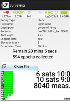
With this graph you can decide that enough data is collected and stop logging manually by pressing Close File button.
¶ 4.1.3 Program receiver to auto finish data logging
JMT programs your receiver to close the static survey automatically so you don’t need to monitor the surveying all the time. Although you can see the surveying status at any time or stop it and close static file then you need this.
¶ 4.1.4 Finish logging
With Logging graph you can decide that enough data have collected and stop logging manually by pressing Close File button. Otherwise J-Mobile stops logging after given period of time. Also J-Mobile programs receiver to stop automatically after given period of time, so you don’t have to monitor recording. Then recording is off receiver LED stops flash.
Then surveying is over recording to file stops. Also JMobile returns from surveying screen to main screen. And you can repeat static surveying for next point.
¶ 4.2 Download raw file to J-Mobile
Go to Receiver Files screen there you can see list of receiver files. Files can be sorted by time to see latest recorded data. Press button near the file name and select Download item. File will be downloaded. You can delete the file on your receiver to free space there. Click action menu near file item and select Delete action.
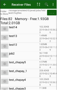
¶ 4.3 Organise data to projects
Downloaded file will be located in logfiles folder of current job folder (e.g. javad/jobs/job1/logfiles for job1)
It will be handled with the job. So, then you export your job the files will be zipped into the job archive.
¶ 4.4 Data exchange
Raw JPS file can be sending/exported. Go to Process item (either from home screen item or from drawer left menu), click to icon button near required item or select several items using Select command and then click to an icon button. Select Share item. Then standart Android Share screen appears. And you can share the file or zipped files with e-mail, clouds, messengers etc.
¶ 5 Process the file with DPOS on JMT
After surveying is over, it is required wait several time to base file will be available on CORS. Some CORSes deliver files every 3 hours, some once a day. After the time process will be successful, otherwise you will get response “No CORS in range”, that means can’t load base files for any reason.
After the file(s) has been downloaded to the controller you can process jps files to compute coordinates using NGS OPUS (works only in USA) or JAVAD DPOS (works in USA and where DPOS servers are installed).
Select Process command on the drawler menu or home screen and the list of downloaded files appears. The files can be arranged the same ways as described above for other lists: they can be sorted using the list, map and calendar.
To operate with a file, tap an icon near it. The list of commands What to do with the file appears.
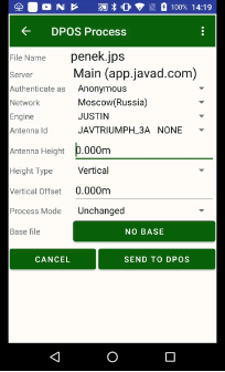
You can delete the file or process it with OPUS or with DPOS. Select Process DPOS menu item. Process DPOS dialog appears.
There you can Network and Engine. JMT had analyzed the file, read antenna data and position and tried to select best Network. You can change it with this dialog. Also, you can set which server will be used for processing. DPOS allows setting up your own DPOS servers.
Note: For details contact JAVAD GNSS DPOS Team.
Also, user can authorize to DPOS server or process file as Anonymous. Authorized process results will be stored on DPOS server also. User can see/download results from server during several days. Anonymous process results will not be saved on server.
Set antenna type and height, select process mode. Press Send to DPOS button. Process starts.
JMT displays process.
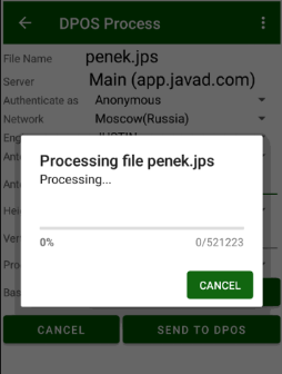
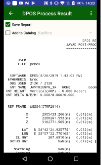
Then process is over, result dialog appears.
If everything is OK, JMT extracts coordinates and Add to Catalog check box appears. Set the checkbox to save result processed point to selected catalog.
The report can be seen at any time by tapping the file and selecting View OPUS or View DPOS item from command menu.
¶ 4.5 Store results.
JMT stores DPOS results into catalogs. Catalog is job independent feature – list of points. Then you can use the catalog for localization or export to design point etc.
¶ 6. VB-RTK
Get on the Grid with VB-RTK. A significant share of OPUS users are surveyors using RTK. Often a surveyor will set up his base on a new, unknown position and allow an autonomous (or standalone) position to be used for the base coordinates. While he is performing his RTK work with fixed vectors between his base and rover, he stores data at the base to be submitted at a later time to OPUS. Once he is finished with his work, he downloads this file to his computer, converts the file if necessary, and submits it to OPUS. He then receives an email response back with a precisely determined coordinate for his base station. He then must take this coordinate, relate the coordinate to his project coordinate system, and then translate the work from the autonomous (or standalone) position he used in the field to this new coordinate. This procedure can produce excellent results and anchors the survey to the NSRS. The down side to this is that there are several steps that must be carefully observed and each of these error prone steps costs time.
With JMT data collection software, Javad has been automating many tasks that surveyors have been doing for years, making the tasks more efficient and reducing sources of potential error. One example, Verify survey, is being recognized by surveyors across the country as the most accurate and efficient way to confidently determine RTK positions. Rather than taking a shot, manually resetting (or dumping) the receiver and taking a second shot for comparison, Verify RTK does this automatically with a user defined Verification in settings.
Javad has continued this automation philosophy by dramatically simplifying the process of translating a survey from an autonomous base position to precise geodetic coordinates with VB-RTK (Verify Base – RTK). Using the Javad GNSS, Data Processing Online Service (DPOS), which is powered by the proven Javad GNSS Justin processing engine. This multi-level process is done in J-Filed completely automatically. In JMT no such automation, but then your RTK Base recorded raw file and your rover stores rover positions from this base, after process on OPUS/DPOS you can adjust (shift) the RTK Base position and correct all the rover points.
That’s why you don’t have to setup RTK Base to precise geodetic coordinates – the correct rover coordinates will be computed by DPOS/OPUS coordinates. This work mode is called VB-RTK.
Then you process your base file in the report you will see VB-RTK button. Pressing on it show list of rover points with their current and new coordinates. You can adjust them pressing Do VB-RTK button.
Once an RTK session has been completed, the user returns to his Javad base receiver, connect it in RTK Base screen and presses “Stop Base” in the JMT. At this point, JMT asks to switch to Receiver Files and download the raw data file that has been recording at the base during the session. When the download is complete, the file can be processed and after result all rover points the can be adjusted to precise positions.
In addition to the advantages of having your RTK base station near your work area, which gives you much more accurate and faster fixes, especially in difficult areas, and saving you the RTN chargest; perhaps most important of all, your work is now precisely related to one of the most accurate geodetic control networks in history - the NGS CORPS. Every rover point is only two vectors removed from the CORS (CORS to base, base to rover). This means that you can return again someday to find your monuments easily and accurately. This makes your records incredibly more valuable to both you and future surveyors.
¶ 7. Hybrid RTK
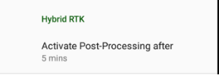
Then you work in a canopy place or with large interference place and can’t get good fix solution for a long time, Hybrid RTK mode saves you. Hybrid RTK mode is activated in survey settings. Just set period of time that you expect to have robust post-processing file. Then Hybrid RTK is activated for each survey point a corresponding raw file started to collect. (JAVAD GNSS receivers can collect two files, that’s why this will not harm your main raw file.) The file name includes your job name and the point name.
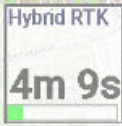
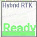
You can control status of Hybrid RTK in Additional View Hybrid RTK item – in Orginize View dialog set check box View Additional Views and select Hybrid RTK with long click to some item. The item shows either remain time or ready status.
In this mode surveyor just do his standard RTK surveying job, collecting sites. Activating Hybrid RTK mode J-Mobiles starts collect raw data file at start of a site surveying. Then fixed RTK solution is reached, the file will be removed automatically. But if survey conditions are bad and no RTK fix for the given time, at the end of surveying a temporary point with autonomous coordinates will be created, and the file remained in the receiver. It can be DPOSed further to obtain correct coordinates for the point. Minimal time for file that can be processed with DPOS service in his conditions, usually this is at least 5 minutes, can be set in survey setting. DPOS service working in your region is required for this mode!
To make Hybrid RTK do following steps:
- Create project, Start RTK Rover and switch to RTK Survey
- In survey settings set check mark Hybrid RTK and set minimal time for raw file to be processed with DPOS.
Also set Fixed only in Use epoch filter. - Start survey point in poor condition. J-Mobile stores additional raw file for each point with the same file name. User can set HybridRTK information panel in addition views in survey screen.
- If RTK Fixed reached a standard point will be created and the raw file will be removed automatically.
- If no RTK fix for the given time, user can stop surveying manually and the point will be created with standalone coordinates and the HybridRTK raw file with name of the point and job name are remain in the receiver memory.
- Then all your data collected and base stations of DPOS service has data (it takes time depends on how often your DPOS bases update files - some services do this every hour other one day), you can download the HybridRTK files and process them to obtain correct coordinates
- Go to Receiver Files and select Download HybridRTK files. J-Mobile tries download files using combination of job name and point names as file names. After that program asks you to switch to Process.
- Go to Process and select Process HybridRTK. J-Mobile selects HybridRTK files and send them to DPOS to process. Then Hybrid RTK Result screen appears and correct coordinates will be set for the points.